Map server - http://mapy.mk.cvut.cz מבחר מפות ותצאו"ת מיוחדות

Map server - http://mapy.mk.cvut.cz
...I tried to collect some maps which are more difficult to get. They cover whole world and they are in digital form... With cooperation with other folks and searching on Internet this collection incredibly raised during last few months. Nowadays the data volume on this server is 19GB!
מכיל מפות מיוחדות בהם בק"מ 1:50000 וגם תצאו"ת ממקומות שונים בעולם
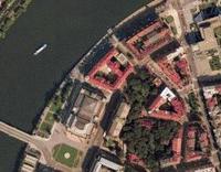
מתוך האתר: תצ"א של הרובע היהודי בפרג
Topographical Maps - scale 1:100,000 South-eastern corner of Poland
South-eastern corner of Poland Topographical Maps - scale 1:100,000These are high resolution [ 100,000 : 1 ] maps of the south-eastern corner of Poland, with a small encroachment into Ukraine and the Slovak Republic. These maps were recently released for public use by the Headquarters of the Polish Army, Carthographic Division, Warsaw 1994. Each centimeter corresponds to 1 kilometer, or 1 inch equals approximately 1.5 miles. Therefore on individual maps, the grid is 2 km x 2 km. Due to high resolution, each of these maps is about 300 kb in size, so you might wish to view these while at work or schule.


